


Garmin Edge 520
15.12.15 11:41 1.2932015-12-15T11:41:00+01:00Text: Erwin Haiden (translated by AI)Photos: Erwin HaidenWith the Edge 520, Garmin has achieved a great success. The long-awaited successor to the 500 series is the Swiss Army knife among GPS bike computers and the new benchmark among compact GPS units.15.12.15 11:41 1.5962015-12-15T11:41:00+01:00Garmin Edge 520
15.12.15 11:41 1.5962015-12-15T11:41:00+01:00 Erwin Haiden (translated by AI) Erwin HaidenWith the Edge 520, Garmin has achieved a great success. The long-awaited successor to the 500 series is the Swiss Army knife among GPS bike computers and the new benchmark among compact GPS units.15.12.15 11:41 1.5962015-12-15T11:41:00+01:00

It's here! It took a long time for Garmin to bring a true successor to the popular Edge 500 to the market with the Edge 520. While the 510 was significantly larger and came with a touchscreen, the developers seem to have gone back to old values with the new 520. Thus, the Edge 520 is really compact, hardly larger than the 500, but it looks more sophisticated and stylish thanks to modern design. The inner values are also convincing, because the small case is packed with sensors and interfaces and offers the ambitious biker a powerful range of possibilities for display, evaluation, live connection, and much more. Both the display and the operation are a big step in the right direction, and the fact that a missing touchscreen is not necessarily a disadvantage, I will go into detail later.


General Features
- Strava integration
- GPS + Glonass
- Map display (including from OpenMaps)
- FTP test and recording
- Recovery suggestions and VO2 Max estimation
- Bluetooth notifications
- Cycling Dynamics Integration
- Simpler uploading of tracks via BaseCamp
- Connectivity with Garmin Varia systems (light + radar)
- ANT+ Trainer Control for Tacx, Kickr, etc.
- Program interface for third-party providers via Garmin Connect IQ
Tech Specs
| Dimensions: | 4.9 x 7.3 x 2.1 cm | Receiver: | GPS + Glonass |
| Display Size: | 3.5 x 4.7 cm | Altimeter: | barometric |
| Weight: | 60g | Memory Cards: | No |
| Battery Life: | approx. 15h | Internal Storage: | 100MB (50MB of that original map) |
| Price: | € 309,- single unit € 389,- bundle with heart rate sensor | Connections: | Bluetooth, ANT+, USB |

Mount
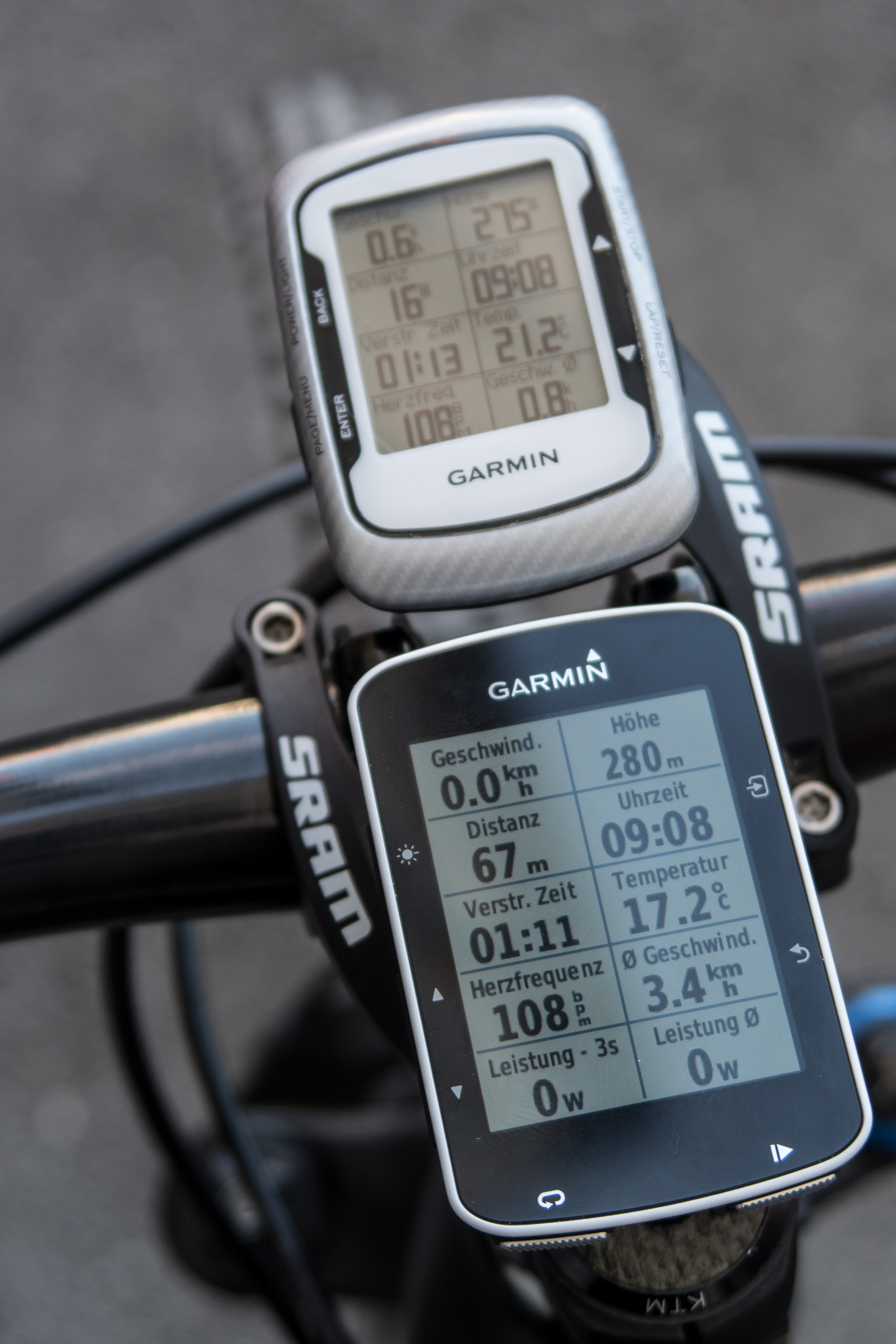
In addition to the simple, rubber band fixed and extremely flexible Garmin standard mount, the Edge 520 also comes with the Aero handlebar mount. Until now, I was a fan of the Sram handlebar mount. For our review bikes, I now prefer the Garmin mount because it is a bit more flexible. It also works with 35 mm thick handlebars, with squarer stems like the Bontrager XXX, and thanks to the joint, it is also a bit easier to mount. On the racing bike, it ensures an ideal position of the speedometer in the field of view in front of the handlebars, on the bike I prefer the central mount above the stem. Compared to various Ahead mounts, the angle with the Garmin system can be perfectly adjusted.


Display
A very important point with all bicycle computers is a well-readable display. In my opinion, the benchmark in this category has been set by SRM with the PC8, which almost works like Amazon's Kindle. I was also impressed with Polar's M400, which, however, can display significantly less information than the also well-readable display of the Garmin Edge 500. Here is a comparison review Garmin 500 vs. 800, where you can also see the weaknesses of the color displays at that time. The higher battery consumption is one reason why I have preferred bike computers with monochrome displays until now.
The display on the Edge 520 does not have a touchscreen, and for me, this is a big advantage in many respects. It is significantly easier to read in difficult lighting situations than the well-known touchscreens of Garmin Edge 510 or 1000. Accidental operation when wiping away raindrops is ruled out, and in winter with thick gloves, the buttons are easier to operate than the touchscreen. In general, readability in most lighting situations is comparable to the Edge 500. Even in the forest or with changing light and shadow, background lighting is not necessary. The Edge 520 loves backlighting, the only time it gets a bit dark is when the low sun shines from behind onto the display. If one wants to find a point of criticism, it is the choice of fonts. A different font could improve readability a little more, especially when there is a lot of information on the display.


Operation
Admittedly, switching from the Edge 500 to the 520 means relearning here and there. The positions of the buttons have changed a little and of course, there are two more buttons. But after a short phase of acclimatization, there was no turning back. With the new operating concept, accidentally starting, stopping, or deleting the recording is now virtually impossible. For example, the displays (map, speed, etc.) only appear when a recording is taking place. If you press stop, a menu immediately appears with the option to save or discard the recording. In addition to the usual options to configure display pages, there are also activity profiles, where you can differentiate between, for example, a road bike (with a power meter), mountain bike, or mountaineering.
In general, Garmin seems to have learned from the small usability weaknesses of the past. The menu navigation of the Edge 520 now seems much more thoughtful and organized, and most functions are largely self-explanatory. Some menus appear context-related (map zoom, Strava segments, Live Track, etc.) This is complemented by the new version of Garmin Connect Online and the iOS and Android apps, which have been modernized and are now continuously updated in short cycles.


From a hardware perspective, buttons instead of a touchscreen, as mentioned above, not only have the advantage of better readability, but the buttons are also easier to hit with thick gloves, and a wet screen does not lead to unintentional operation when swiping over it. All in all, I now find the operation to be well-rounded.


Bluetooth and ANT+ Connections
A must for power users has always been the ability to connect a heart rate strap, pulse arm band, power meter, cadence and speed sensor, and much more with ANT+ or Bluetooth. This works thanks to simple menu navigation that is self-explanatory. The sensors, once paired, also connect very quickly and with feedback on the display. The smartphone is paired via Bluetooth and the communication works in both directions. On the one hand, calls are displayed on the Edge 520's display, and on the other hand, the Edge can communicate with Garmin Connect via the smartphone, thus making a live track available or automatically saving the latest activities.


Data Recording and GPS Accuracy
For me, the following procedure has proven to be ideal. I start the Garmin after putting on the heart rate strap and turning the crank once (to wake up the power meter). Within a few seconds, the power meter, pulse, and mobile phone are recognized and paired. Within about 30-60 seconds, I also get GPS reception in the anteroom. When leaving the house, I then press Start and "Current altitude calibrated" appears on the display. Upon returning, I press Stop and save the tour, which is online in the private area on Garmin Connect just a few seconds later.
For intervals, I have always chosen "Record every second" (in the menu Settings -> System -> Data Recording). In the activity profile, I only activated the "Auto Pause". Besides the much faster GPS reception, I noticed from the beginning the higher accuracy. The problems that the Edge 500 had along terrain edges are a thing of the past. Generally, the 520 was precise on the track in most situations - a significant improvement over the 500. Heart rate and power measurements were also accurate. The problems with live tracking were fixed with a software update of the app. There were only minor issues with the first software version or when mountain climbing or climbing in very steep terrain.


Installation of Maps
Step 1:
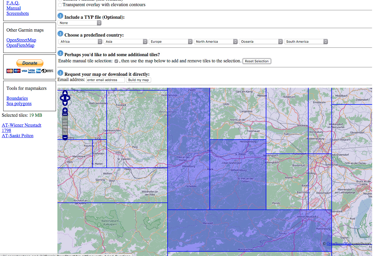
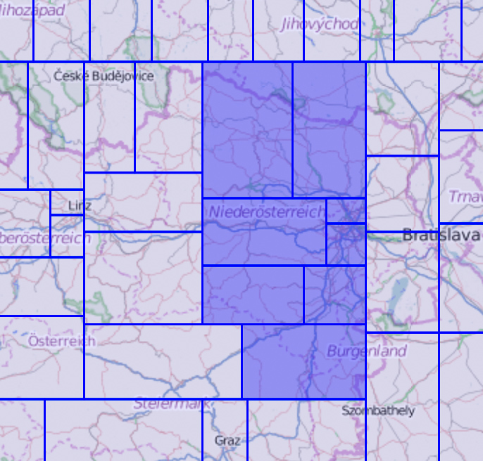
- On this page, you can find the maps for download: http://garmin.openstreetmap.nl/
- Choose "Routable Bicycle" or "Generic Routable New Style" as your map type
- At "additional tiles", reset the selection to zero with "Reset Selection" and now you can select map areas
- Make sure that the map is not larger than about 40-60 MB
- After that, enter your email address and press "build my map"
You will soon receive an email with the confirmation and another 20-40 minutes later with the download link for your individual map.
Step 2:
- connect your Garmin to the computer
- in the Garmin folder, you will find a file "gmapbmap.img". Backup this (original) file on your computer
- Delete the file "gmapbmap.img" on the Garmin (on a Mac you must then also empty the trash)
Step 3:
- Download the file with the ending *_gmapsupp.zip
- extract the file
- Copy the file gmapsupp.img into the Garmin directory on the Edge 520 (where the original file was)
- Rename the file gmapsupp.img now to gmapbmap.img
After restarting the device, the map should be displayed correctly.
Alternatives
Two more links are worth mentioning here, without going into the technical details of the installation:
The most comprehensive tool at the moment to get maps onto the Edge 520:
http://extract.bbbike.org/?lang=de
Another Open Street Map provider or converter for Garmin Basecamp or QLandkarte
http://garmin.opentopomap.org/
Sure, here is the translation for the text you provided: """Navigation
The Edge 520 may not have routing capabilities, but as described above, it offers map representation via Openstreetmap. Currently, this is not yet possible directly through Garmin but through a third-party site, which works relatively easily.
The map display is excellent, and once the appropriate scale is set, I hardly felt the need to change the zoom factor anymore.
The navigation stress test was the 2rcformatc in the fall, where the goal was to find as many geocaches as possible in a short time. Our preparation: After 4-5 beers at 2 am, connecting the GPS points pilfered by colleagues into a sensible line. 15 min. later, I loaded the track onto the device via BaseCamp and lo and behold, the POI (Points of Interest) were visible on the display. The result: 2 hours of riding time, on and off-road, 12 km, 700 vertical meters, and 8 caches, which would have definitely taken longer without the Edge 520.


The map provides enough information at crossroads to find the right way or even short-term alternatives (with fewer meters of altitude) without having to stop. By now, I have completed several short, long, and multi-day tours on roads and off-road, and I am still excited about the possibilities that this rather small display offers. However, the small device is not suitable for creating and editing tracks and tours.


Strava
The Strava Live Segments are truly devilish things. There you are, sitting sleepily with your breakfast coffee, activating your Strava account, only moments later to blaze uphill like a madman, pulse racing, eyes on the display, the ever-growing deficit in sight. For those who suddenly race without a racetrack, somewhere in the middle of nowhere, against acquaintances and strangers, against themselves and time, it's already too late.
A premium account with Strava is a prerequisite for the live segments. Right after uploading my first training ride, I see several segments on my local loop that someone created before my time with Strava. Favourite segments are automatically synchronized and activated with the Garmin. On the device, you can then choose the pace (KOM, friend XY, or your own best time) or deactivate entire segments. As you approach the next segment, the display shows the segment name and the countdown in meters to the start. While you're in the segment, you get the information about the remaining distance and the lead or deficit to the chosen pace.
Even though I count myself more among the pleasure cyclists and anti-racers, the racing fever has somehow grabbed me because suddenly you have a virtual opponent in front of you who motivates. If you don't choose the Grossglockner with Hans Peter Obwaller as your segment and pace, but the hill on your local loop with your own best time, you can see quite clearly during the ride where you are losing time or catching up, or also, which bike performs well uphill.


Garmin Connect or where to put the data
Regarding evaluation, Garmin now offers all possibilities. Via smartphone, you can automatically synchronize the Edge, provided that the checkbox is ticked in the app. However, you can also synchronize the device manually via USB cable, and Garmin Connect is not a must. Although it offers numerous interfaces to all kinds of programs, for users who do not want their training online and prefer to import directly into WKO+ or similar software, syncing works the old-fashioned way via USB.
The device itself provides some evaluations of the last ride and informs about achieved goals, recommended rest periods, tour data, and also calculates data like FTP or similar. For the latter, there's the following procedure:
Option 1:
Warm up and hold out for 60 min. without stopping, never stopping or driving off, always on effort, and the last minutes to the point of absolute explosion
Option 2:
5' all out
Little break
20' all out
FTP = 20' Watt-Avg minus 5%
")

 and statistics")


Criticism
Despite intensive use, there were hardly any real weaknesses that the Edge 520 exhibited. The worst was a crash in the first software version. After 7 hours of riding time along a track, the display froze. The power button then caused the power symbol to stay on the display for about 1 hour, without the possibility to intervene. Afterwards, the device restarted and everything worked as usual. Only the log of the day was empty, and even Garmin Connect could not read anything out. However, the .fit file was present and could be imported manually.
Another point is the backlight, for which there is a button, but it leads to the display showing the brightness levels. Only with a second click do you get back to the current screen.
When navigating along Strava segments, the map section is very large, i.e. you do not see any details and junctions, and you also have no possibility to change the zoom factor. In that case, you have to switch to the map view.
The temperature sensor now works relatively well at colder temperatures but showed temperatures that were 5-6°C too low in September and October at 20°C.
Most points will perhaps be fixed with one of the next firmware updates. In general, I would like the modern Garmin Connect to allow for online configuration of the Edge 520 in the future. Similar to SRM, where you can set display elements easily via drag & drop, such a feature would be a fine thing due to the sheer range of functions of the Edge and would make configuration and switching much easier.


| Garmin Edge 520 | |
|---|---|
| Test duration: | 3 months, >1,000 km |
| + | Compact form |
| + | Readable color display |
| + | Versatility / Range of functions |
| + | GPS accuracy |
| + | Navigation |
| + | Strava Live Segments |
| + | Operation / Menu navigation |
| o | No online configuration |
| o | Temperature sensor not always accurate |
| o | Minor software issues (Backlight only with double-click, no zoom in elevation profile and for segments) |
| - | Minor software bugs with the first firmware |
| BB-Verdict: | The new benchmark in terms of bicycle computers |
The Garmin Edge 520 is a milestone in terms of bicycle computers and, for me, the new benchmark in this category. It combines numerous essential functions and advantages that make it the perfect companion and all-around tool. First in my internal hit list ranking are the GPS accuracy, the compact size, the legible display, the many interfaces to sensors or to the smartphone, the ability to load maps onto the device, to follow tracks, the Strava integration, and much more.
In certain areas, there may be devices that can do certain things better. An Edge 1000 offers more display space for navigation, the also new Garmin Edge 25 is uncompromisingly small, but the sum of the possibilities in this compact form make the Garmin Edge 520 the ultimate Swiss Army knife among bicycle computers and, in my view, unique at the moment.
In the first three months, the device hardly showed any weaknesses, even survived a (unintentional) 40° wash and a few minutes in the tumble dryer. The Edge 520 was an important companion in reviews, for data recording in the mountains, or as a navigation aid on unfamiliar paths, and so my old 500 can retire after five years or find a new home.
Comments / Update
Write to us in the thread if something interests you. The report will be updated if there are any news or if something else comes to our attention about the device.


