


Garmin Edge 820 in Review
09.09.16 17:42 2.3112016-09-09T17:42:00+02:00Text: Armin Reautschnig (translated by AI)Photos: Armin Reautschnig, Erwin Haiden, Luke Biketalker, GarminThe new Garmin Edge 820 is a transformer between worlds. Cut from the same cloth as last year's Edge 520, the inside hides the capabilities of the Edge 1000. And much more...09.09.16 17:42 2.3622016-09-09T17:42:00+02:00Garmin Edge 820 in Review
09.09.16 17:42 2.3622016-09-09T17:42:00+02:00 Armin Reautschnig (translated by AI) Armin Reautschnig, Erwin Haiden, Luke Biketalker, GarminThe new Garmin Edge 820 is a transformer between worlds. Cut from the same cloth as last year's Edge 520, the inside hides the capabilities of the Edge 1000. And much more...09.09.16 17:42 2.3622016-09-09T17:42:00+02:00

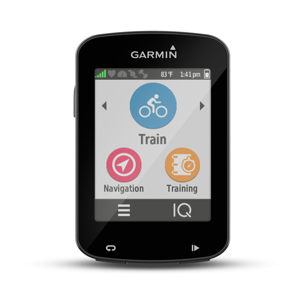
Anyone who thinks of the Edge 820 as just a facelift of the Edge 520 at first glance will start to wonder at the second glance. Where have all the buttons gone? They have given way to a touchscreen. Not all of them, as the functions for On/Off, Start/Stop, and Lap are still operated with buttons in the usual places; otherwise, however, tapping and swiping is the order of the day as much as your fingers can manage.
But under the hood, Garmin has been busy tinkering as well. For example, the internal memory has been increased to a generous 16 GB. The device is now routing-capable and also reliably provides information about upcoming direction changes on trails to stay on course. The live connectivity introduced in the Edge 520 has been expanded with GroupTrack and the possibilities for data analysis have become even more comprehensive.
The Edge 520 was "the Swiss Army knife among GPS bike computers"; the Edge 820 is the Swiss Army knife 2.0.
Excerpt of the New Features in the Edge 820
- Touchscreen
- routing-capable (Turn-by-Turn navigation with rerouting if you deviate from the route)
- 16 GB internal memory (therefore no longer possible to use micro-SD cards)
- Audio output of routing instructions, alerts, etc. through a connected smartphone
- Incident detection with subsequent notification of a designated contact person
- GroupTrack
- WiFi
- Power saving mode


Tech Specs"""(Translation: Technische Daten)
| Dimensions: | 4.9 x 7.3 x 2.1 cm |
| Display size: | 3.5 x 4.7 cm |
| Display resolution: | 200 x 265 pixels |
| Touchscreen: | yes |
| Weight: | 67.7 g |
| Receiver: | GPS + Glonass |
| Altimeter: | barometric |
| Memory cards: | No |
| Internal storage: | 16 GB (6.7 GB of which is occupied by maps) |
| Battery life: | approx. 15 h (with the new power-saving mode, the battery will run out before then, Garmin says +50% runtime with further recording of tour details) |
| Connections: | WiFi, Bluetooth, ANT+, USB |
| Price: | € 399,- single device, € 499,- bundle with heart rate sensor |
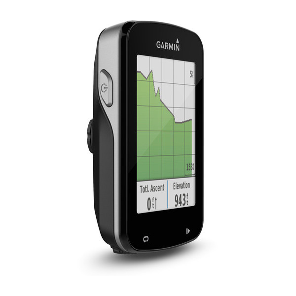
Display with a Fondness for Gentle Touches
The display is good; excellent, I might even say. The readability of the displayed content is very good in any weather condition. (The only critique about the display is a pixel error that appeared after ten hours of operation and forced NoMan, because of my fussiness, into a moderate fit of laughter.)
However, the touch function seems somewhat indecisive. It doesn't quite know whether it's on the sensitive side or if it's stubborn like a mule at heart. With gloves on (well-equipped for operating capacitive touchscreens), the Edge only responded to tapping, but not to swiping gestures for changing training pages. Moreover, tapping was mostly interpreted as an up/down swiping gesture. (I do not want to exclude a connection with my own stubborn fine motor skills.)
In trying to emphasize the swiping through a certain temporal persistence, I discovered the possibility to change the individual data fields on the training pages quasi "on-the-fly." Practical, but only partially satisfying if you want to flip to the next page. (By pressing and holding on a data field, the selection menu for the available contents appears. This way, the training pages can be edited directly without having to go the long way through Settings > Activity Profiles > Training Pages.)


Once you set aside the gloves, sometimes a rapid approach or a close hover with the finger is enough to elicit a response from the display. However, in most cases, the Garmin does not guess where one intended to click. Therefore, this "magic trick" becomes annoying over time.
Over time, I have also become accustomed to these peculiarities and wouldn't want to do without the touchscreen anymore. A direct comparison with the Edge 520 during an extended review session has not only reinforced this feeling in me but also tempted NoMan, as an Edge 520 user, to occasionally tap on the display of her device. Tapping on various screens seems to have become second nature to us.
How the operation of the Edge 820 will be in the upcoming cold season with thick gloves remains to be seen. Maybe then the old reliable 'sausage trick' will have to be used again.

Hands-on
To match the new user experience provided by the touchscreen, the Edge 820 has also been given a new interface design, which is distinctly different from the button-dominated Edge 520. The layout of the main page includes the status bar at the top edge, the task bar at the bottom edge, and the "task area," where the three large functions "Navigation," "Activity," and "Training" are prominently placed.
The design of the menus seems to me, with a few exceptions, to be very well done. And the various shortcuts that the touchscreen allows also simplify the operation. For example, if you press and hold the "Back" arrow at the lower left corner of the display long enough, you will be sent straight back to the Edge 820's home page. This is a clear usability advantage, especially in the sometimes quite nested menus.
Basically, there are two ways to handle devices of this level of complexity: Either you spend three days reading the various "In-depth" instruction manuals, or you press and swipe over every conceivable element that appears on the display.
The included quick start guide suggests that Garmin, like me, tends to belong to the second group. And those who belong to the second group will not only be pleased with the device itself but also with every discovery of a new trick - provided they have some perseverance.
For the basic tasks, even this brief introduction is not necessary. The symbols are self-explanatory and pairing ANT+ sensors and accessories, for example, is effortless. If you delve a little deeper into the offered capabilities, a different picture sometimes emerges. Certain features, such as sharing data between two devices, feel somewhat clunky to use and require multiple attempts to achieve a positive outcome.

Maps
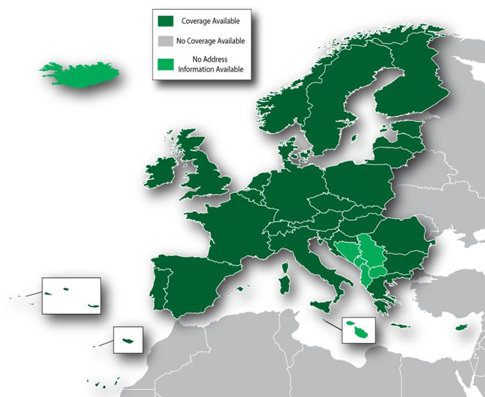
The Garmin Edge 820 does not have a microSD card slot, unlike the Edge 1000, but it comes with a generous 16 GB of internal storage (the Edge 520 only has 100 MB). Half of this storage is filled with a routing-capable bicycle map for Europe. The level of detail on the map is very good and the coverage is impressive. There's no immediate need to switch to an alternative map (e.g., Openstreetmap). However, since there is an abundance of storage, I tried it anyway and loaded a "section" of the Openstreetmap maps onto the Edge 820.
In principle, the process of installing the maps is the same as with the Edge 520, but due to the storage space and the ability to activate/deactivate maps on the device itself, there are a few changes:
- The source of map joy remains openstreetmap.nl. For Maptype, I focused on "Generic Routable New Style" ("Routable Bicycle" works as well).
- After the selection at "additional tiles" has been reset with a click on "Reset Selection", you can select the desired map sections. Thanks to the huge storage, you do not have to be restrained.
- Once the sections are chosen, enter your email address and press "build my map".
- Shortly, a confirmation email will arrive in your inbox, and depending on server load and the size of the sections, sooner or later (it took just under 20 minutes for my selection) an email with the download link for your map will follow.


 The Edge 820 just gives a very, very weary smile at that cost. With the pre-installed Europe map and the OSM excerpt, there is still plenty of room for moreThe Edge 820 just gives a very, very weary smile at that cost. With the pre-installed Europe map and the OSM excerpt, there is still plenty of room for more


Connect your Garmin to the computer (I did not remove the "gmapbmap.img" file, more on that in step 4)
Step 3:
- Download the file with the suffix "*_gmapsupp.zip" (there are also files available for use in Basecamp) and extract it.
- Copy the "gmapsupp.img" file into the "Garmin" directory on the Edge 820 (where there are already some files with the ".img" extension).
- After restarting the device, the map is available.
Step 4:
To display the map on the Edge 820, you can activate or deactivate the existing maps in the settings of the activity profiles (Settings > Activity Profiles > Navigation > Map > Map Information). Unfortunately, this setting is global for the Edge 820 and it is not possible to use different maps for different activities. Perhaps this feature will be added with one of the next updates, as the setting is available separately in each activity profile.
Navigation
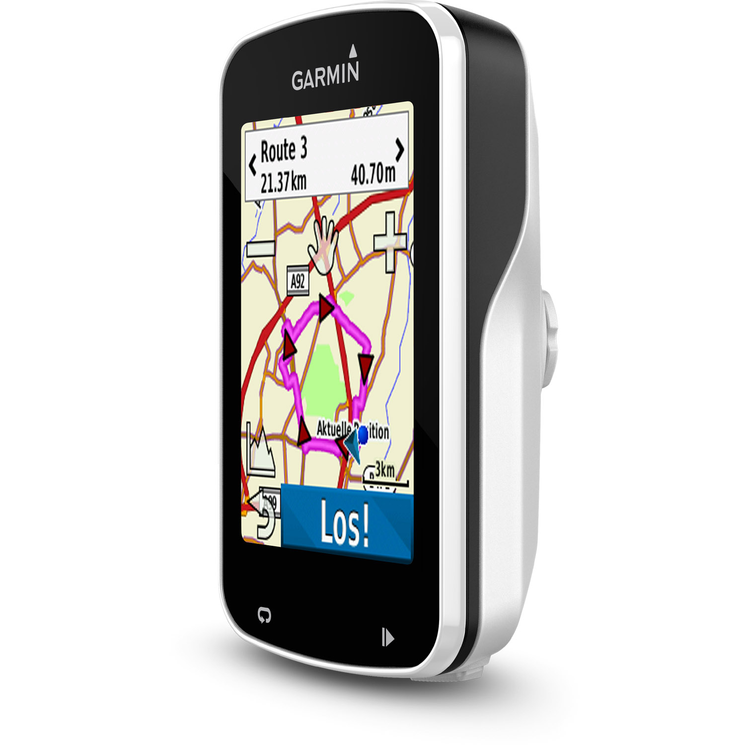
The new Garmin Edge 820, like its big brother Edge 1000, is capable of routing and certainly helps when you find yourself off the beaten path in the city, or simply want to focus on riding without constantly having to keep the destination in mind. Finding addresses is quick and easy, and so is creating a route. However, the ultimate stress test for such a system is the recalculating of the route after you have - intentionally or unintentionally - passed a turn. But here too, the Edge 820 does not show any weaknesses.
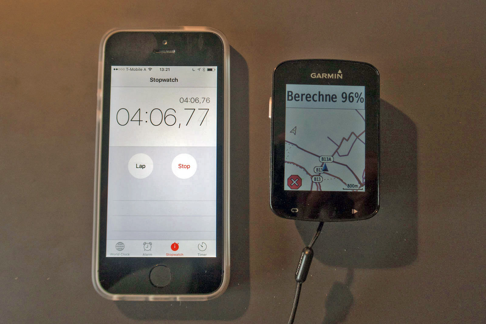
What was surprising, however, was the amount of time the device took to route a pre-made GPX track. Calculating the nearly 20-kilometer long tour took over four minutes. To exclude any background activities related to the connected iPhone, I repeated the process with Bluetooth/WiFi turned off. The result remained unchanged.
 18,843 points")
 2,913 points")
The routing on the route then worked very well. Thanks to GPS and GLONASS, even deeper ditches and densely forested passages are not a problem at all. Checking the recorded tracks in Garmin's own tracker creation tool Basecamp showed that the deviations from the map are kept within very tight limits. The difference due to the two available recording intervals (1 second or "intelligent") is also not very large. Most deviations were rather caused by the fact that not two Garmins were mounted on one handlebar, but the tour companion was riding with their own device.

GroupTrack: LiveTrack with Increased Communication Needs
The recent Garmin products mostly feature the LiveTrack feature, which allows the current position and other motion data to be tracked live online. In the new Edge 820, Garmin goes a step further and brings the LiveTrack data of friends onto the display.
In the atmospheric world of Garmin, this is what it looks like when three friends meet for a ride together without the hassle of coordinating meeting points and waiting times:
Unlike LiveTrack, where an invitation to stalk via social media (Facebook and Twitter) or by email can be distributed, with GroupTrack all participants must be connected through Garmin Connect.
Those who only have the LiveTrack feature (e.g.: Edge 520, Edge 1000), can join in the group fun, but will only share their location and will not see the other riders on their own map.
Setting up a GroupTrack for the first time is not entirely intuitive, but once you have grasped the logic behind it, many question marks will be resolved. (At my first attempt, I assumed that I was creating a GroupTrack event and the other competitors would "join" it. It turned out that each participant creates a GroupTrack event and the events connect with each other.)
 The feasibility study was ultimately successful, despite a bumpy start. Even if this use case is somewhat far from reality. GroupTrack in Action: Invite participants to GroupTrack, start LiveTrack, start activity and then your own position appears on the display of the other participants.The feasibility study was ultimately successful, despite a bumpy start. Even if this use case is somewhat far from reality. GroupTrack in Action: Invite participants to GroupTrack, start LiveTrack, start activity and then your own position appears on the display of the other participants.

In addition to the effectively advertised ride coordination, GroupTrack could also prove useful when a group on a tour - due to differences in performance or mechanical issues - falls apart. Uphill, the leaders can quickly check the map to see if a quick standing beer at the summit inn is still possible without being noticed, downhill it can be quickly decided whether to cycle back to a positionally stable group member or whether a call should be made ahead because it is faster.

Garmin Connect - where everything comes together
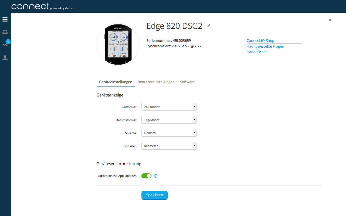
The web platform Garmin Connect is something like the workbench for the preparation and follow-up of activities with the Edge 820. From managing routes and segments to creating training plans to the subsequent review of one's own heroic deeds, everything is done via the website. The Edge 820 itself can also be configured to a certain extent there.
The synchronization of all these data is then done via Garmin Express. However, the device must be connected to the computer via a USB cable.
This is where the Garmin Connect Mobile App comes into play. Since the app accesses the same data as the web platform, the synchronization of routes, settings, etc., can be done wirelessly via the smartphone if there is a Bluetooth connection to the Edge 820. Goodbye to cable clutter.
If one can do without creating routes and segments, the management of the Edge directly via the app is sufficient. However, it should be mentioned that the app is not without fault. How well the app itself and the communication with the Edge works is highly dependent on the smartphone the app runs on, or is supposed to run on. On a Sony Xperia Z3 compact, just installing the app led to a complete system crash that could not be resolved. In my case, it worked flawlessly with an iPhone SE so far.

 was still waiting for the connection to be established, the receiving Edge 520 (above) had already got what it wanted.")
 was still waiting for the connection to be established, the receiving Edge 520 (above) had already got what it wanted.") While the transmitting Edge 820 (below) was still waiting for the connection to be established, the receiving Edge 520 (above) had already got what it wanted.While the transmitting Edge 820 (below) was still waiting for the connection to be established, the receiving Edge 520 (above) had already got what it wanted.
While the transmitting Edge 820 (below) was still waiting for the connection to be established, the receiving Edge 520 (above) had already got what it wanted.While the transmitting Edge 820 (below) was still waiting for the connection to be established, the receiving Edge 520 (above) had already got what it wanted.


 was still waiting for the connection to be established, the receiving Edge 520 (above) had already got what it wanted.")
The amount of data produced by the Edge 820 is slightly beyond the limit of easy comprehensibility, and the calculations that Garmin performs with the collected data to hold up the cruel mirror of reality to us with various key figures, require a bit more than just basic arithmetic. Although these calculations are carried out on the Edge 820, the display of the results is limited due to the size of the screen. However, once the activity is saved, the data can be sent directly to Garmin Connect - via Bluetooth and smartphone or over WiFi - the full glory of the evaluation possibilities is immediately available in the app or on Garmin Connect, to revel in the accomplishment of the performance - or not.
. Still, it doesn't make the uphill any easier.")


Detail on the side: On the Edge, the frequency ranges for the training zones can be entered based on BPM. This option is not available in the settings of the Garmin Connect profile. Here, the ranges are calculated using a percentage key. The options include percentage of maximum heart rate, percentage of heart rate reserve, or percentage of lactate threshold heart rate. Although the individual BPM values of the ranges can be manually adjusted, if the value results in a non-whole percentage, it is rounded up to the next whole percentage, and the BPM value is automatically changed. Picky, I know. Still: I don't like.

Criticisms
Due to Garmin's proprietary software policy, this point ended up being shorter than it looked at times. During the test period, two new software versions were provided and installed, which eliminated some initial inconsistencies (e.g., the language was set to German during the first setup, but not all menu items had made it to the translation office – the translation is still not entirely consistent; after two days in the closet (turned off, of course) the battery level showed "full" after turning it on - only to change to "empty" after three minutes of operation;)
That not all errors were eliminated became apparent during an extended hike in the Austrian-Swiss border region. Equipped with its own activity profile, I set off. The Garmin remained in a spacious outer pocket on my backpack. The nasty surprise came when I checked the recording after a good hour of ascent: the Edge 820 seemed to have jumped over the cliff - display dark.
First thought: power-saving mode (surprising, after an extended charging session overnight, but okay). However, a tap on the display did not breathe any life into it. (Waking up also works with the display lock activated. However, the note that the display lock is active is not shown in power-saving mode.) Also, a longer press on the power button to get to the energy options had no effect. Only resetting the Edge 820 (holding the power button for at least 10 seconds) brought it back to life.
A look at the log showed that it had inexplicably signed off from the tour after just over five minutes.


Certainly interesting, but not without problems, is the possibility to switch the activity profile while the timer is running.
During the second hike in the same area, this happened to me unnoticed and unfortunately, the choice fell on "Indoor". This resulted in the deactivation of the GPS functions and thus also in an incomplete recording of the track.
So caution is advised when handling the Edge hands-free - especially due to the sensitive touchscreen mentioned. On the bike, the likelihood of such unintended maneuvers is rather low. Primarily because I rarely find myself in the physical condition to take a hand off the handlebars.
However, I have not yet experienced any interaction with the Edge 820 through sweat droplets landing on the display, as is mentioned in various forums.
Conclusion
| Garmin Edge 820 | |
|---|---|
| Model Year: | 2016 |
| Review Duration: | 2 Months, > 500 km |
| + | a wealth of internal memory |
| + | Turn-by-turn navigation |
| + | small, light, awesome |
| + | top display |
| + | intuitive operation (touchscreen and menu navigation - exceptions confirm the rule) |
| + | range of functions |
| + | accurate thanks to GPS + GLONASS |
| o | Software quirks |
| - | Touch function: hyper- vs. insensitive |
| BB-Verdict: | The Swiss Army Knife 2.0 among GPS bike computers |
With the Edge 820, Garmin has achieved a great success in the compact class of GPS bike computers. Everything that the Edge 520 was already good at (GPS accuracy, map representation, size, display, evaluation possibilities, live connection), the Edge 820 can do too, and improvements have been made in the right places here and there.
The considerable increase in the size of the internal memory, the routing capability, and not least the intuitive operation via the touchscreen, make the 820 a very, very rounded thing.
Some of the new features may prove to be very useful (GroupTrack), others I am glad that they can also be deactivated (automatic accident detection – the experience reports shared here in the forum have satisfied my curiosity enough to be able to skip the self-test.)
Those who don't shy away from touch and are looking for a compact GPS miracle gadget will be very pleased with the Edge 820.
